
Savegre topographic map
Click on the map to display elevation.
About this map
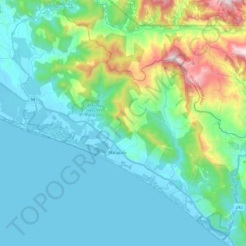
Name: Savegre topographic map, elevation, terrain.
Location: Savegre, Quepos, Puntarenas Province, 60602, Costa Rica (9.25348 -84.04542 9.45014 -83.83904)
Average elevation: 233 m
Minimum elevation: -1 m
Maximum elevation: 1,175 m
Other topographic maps
Click on a map to view its topography, its elevation and its terrain.