
Make a donation
Gear up for your next adventure:
As an Amazon Associate, this site earns from qualifying purchases at no extra cost to you.
Laboule topographic map
Click on the map to display elevation.
Make a donation
Gear up for your next adventure:
As an Amazon Associate, this site earns from qualifying purchases at no extra cost to you.
Laboule
Le village de Laboule est perché à 680 mètres d'altitude, au pied du massif du Tanargue. Il est situé dans le Pays de la Beaume-Drobie, dans le canton de Valgorge, au sud-ouest de l'Ardèche. La plus grande ville à proximité de Laboule est Aubenas, située à environ 36 kilomètres au nord-est.
Make a donation
Gear up for your next adventure:
As an Amazon Associate, this site earns from qualifying purchases at no extra cost to you.
About this map
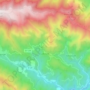
Name: Laboule topographic map, elevation, terrain.
Average elevation: 814 m
Minimum elevation: 338 m
Maximum elevation: 1,447 m
Make a donation
Gear up for your next adventure:
As an Amazon Associate, this site earns from qualifying purchases at no extra cost to you.
Other topographic maps
Click on a map to view its topography, its elevation and its terrain.
Quartier Salavert
France > Auvergne-Rhône-Alpes > Ardèche > Saint-Julien-du-Serre
Average elevation: 329 m
Make a donation
Gear up for your next adventure:
As an Amazon Associate, this site earns from qualifying purchases at no extra cost to you.
Make a donation
Gear up for your next adventure:
As an Amazon Associate, this site earns from qualifying purchases at no extra cost to you.
Make a donation
Gear up for your next adventure:
As an Amazon Associate, this site earns from qualifying purchases at no extra cost to you.