Geolocate

Caliongan topographic map

Click on the map to display elevation.

About this map

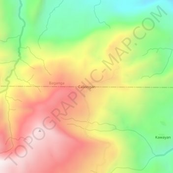
Name: Caliongan topographic map, elevation, terrain.

Location: Caliongan, Caraga, Davao Oriental, Davao Region, Philippines (7.42483 126.32791 7.46483 126.36791)

Average elevation: 968 m

Minimum elevation: 437 m

Maximum elevation: 1,506 m

Gear up for your next adventure:

🥾Light Hiking Boots - Lightweight and comfortable boots for day hikes
🧤Rechargeable Heated Gloves - Extreme warmth for Canadian winter expeditions
🧴First Aid Kit - Essential first aid supplies for outdoor emergencies
🦌Outdoor Trail Camera - Monitor wildlife activity near your favorite spots
🔨Vehicle Emergency Tool - Safety tool for remote road trips to trailheads

As an Amazon Associate, this site earns from qualifying purchases at no extra cost to you.