
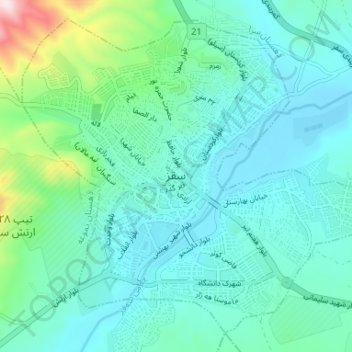
Saqqez topographic map
Interactive map
Click on the map to display elevation.
About this map
Name: Saqqez topographic map, elevation, terrain.
Average elevation: 1,527 m
Minimum elevation: 1,448 m
Maximum elevation: 1,893 m
At an altitude of 1,476 metres (4,842 feet), Saqqez has a Mediterranean continental climate (Köppen climate classification Dsa) with hot, very dry summers and cold, snowy winters. Summers feature large diurnal temperature variation due to decreased air density at high altitude and low humidity. In 1969 Saqqez recorded a temperature of −36 °C (−33 °F), the lowest ever recorded by an Iranian weather station until Kheirabad Zanjan recorded −36.4 °C (−33.5 °F) on January 29, 1997.[13][14] Saqqez again reached −36 °C during the February 3–9 1972 Iran blizzard.
Other topographic maps
Click on a map to view its topography, its elevation and its terrain.
Suteh
Iran > Kurdistan Province > Saqqez County > دهستان چهل چشمه غربی
Suteh, دهستان چهل چشمه غربی, بخش سرشیو, Saqqez County, Kurdistan Province, Iran
Average elevation: 1,779 m
Bastam
Iran > Kurdistan Province > Saqqez County > دهستان چهل چشمه غربی
Bastam, دهستان چهل چشمه غربی, بخش سرشیو, Saqqez County, Kurdistan Province, Iran
Average elevation: 1,793 m
Irab
Iran > Kurdistan Province > Saqqez County > دهستان امام > Irab
Irab, دهستان امام, بخش امام, Saqqez County, Kurdistan Province, Iran
Average elevation: 1,788 m