Geolocate

Senja topographic map

Click on the map to display elevation.

About this map

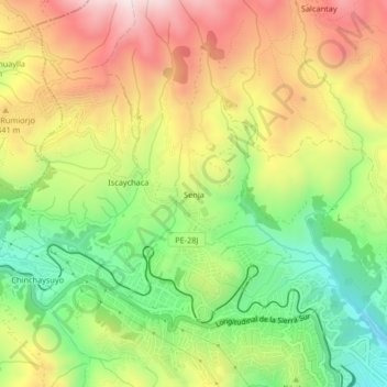
Name: Senja topographic map, elevation, terrain.

Location: Senja, Cusco, Distrito de Cusco, Cusco, 08000, Perú (-13.51441 -72.02659 -13.47441 -71.98659)

Average elevation: 3,761 m

Minimum elevation: 3,443 m

Maximum elevation: 4,115 m

Other topographic maps

Click on a map to view its topography, its elevation and its terrain.

Tampu Mach'ay

Perú > Cusco > Cusco > Huayllarccocha

Average elevation: 3,886 m

Parque el Mapa

Perú > Cusco > Cusco

Average elevation: 3,375 m

Gear up for your next adventure:

🥾Waterproof Hiking Boots - Essential footwear for rugged terrain and wet Canadian trails
🦟Insect Repellent - Keep mosquitoes and black flies away in wooded areas
🔦LED Flashlight - Powerful and long-lasting flashlight for camping and emergencies
🧥Thermal Layer - Insulating layer for cold outdoor conditions
🎒Hiking Backpack - Lightweight and ergonomic backpacks for day hikes or multi-day treks

As an Amazon Associate, this site earns from qualifying purchases at no extra cost to you.