
Make a donation
Gear up for your next adventure:
As an Amazon Associate, this site earns from qualifying purchases at no extra cost to you.
Montaigu topographic map
Click on the map to display elevation.
Make a donation
Gear up for your next adventure:
As an Amazon Associate, this site earns from qualifying purchases at no extra cost to you.
Montaigu
Le territoire municipal de Montaigu s’étend sur 306 hectares. L’altitude moyenne de la commune est de 41 mètres, avec des niveaux fluctuant entre 23 et 57 mètres.
Make a donation
Gear up for your next adventure:
As an Amazon Associate, this site earns from qualifying purchases at no extra cost to you.
About this map
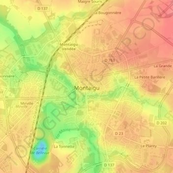
Name: Montaigu topographic map, elevation, terrain.
Average elevation: 46 m
Minimum elevation: -2 m
Maximum elevation: 67 m
Make a donation
Gear up for your next adventure:
As an Amazon Associate, this site earns from qualifying purchases at no extra cost to you.
Other topographic maps
Click on a map to view its topography, its elevation and its terrain.
Le Butay
France > Pays de la Loire > Vendée > Montaigu-Vendée > Saint-Georges-de-Montaigu
Average elevation: 52 m
La Croix Verte
France > Pays de la Loire > Vendée > Montaigu-Vendée > Boufféré
Average elevation: 46 m
La Moctière
France > Pays de la Loire > Vendée > Montaigu-Vendée > Saint-Hilaire-de-Loulay
Average elevation: 63 m
La Dragonnière
France > Pays de la Loire > Vendée > Montaigu-Vendée > Saint-Georges-de-Montaigu
Average elevation: 66 m
Make a donation
Gear up for your next adventure:
As an Amazon Associate, this site earns from qualifying purchases at no extra cost to you.
La Durbelière
France > Pays de la Loire > Vendée > Montaigu-Vendée > Saint-Georges-de-Montaigu
Average elevation: 60 m
La Roche Pépin
France > Pays de la Loire > Vendée > Montaigu-Vendée > Saint-Georges-de-Montaigu
Average elevation: 62 m
Le Bordage Caillé
France > Pays de la Loire > Vendée > Montaigu-Vendée > La Guyonnière
Average elevation: 64 m
La Fossère
France > Pays de la Loire > Vendée > Montaigu-Vendée > La Guyonnière
Average elevation: 69 m
Make a donation
Gear up for your next adventure:
As an Amazon Associate, this site earns from qualifying purchases at no extra cost to you.
La Faubretière
France > Pays de la Loire > Vendée > Montaigu-Vendée > Saint-Georges-de-Montaigu
Average elevation: 55 m
La Daunière
France > Pays de la Loire > Vendée > Montaigu-Vendée > Saint-Georges-de-Montaigu
Average elevation: 55 m
La Richardière
France > Pays de la Loire > Vendée > Montaigu-Vendée > Saint-Hilaire-de-Loulay
Average elevation: 41 m
Make a donation
Gear up for your next adventure:
As an Amazon Associate, this site earns from qualifying purchases at no extra cost to you.
La Templerie
France > Pays de la Loire > Vendée > Montaigu-Vendée > Saint-Georges-de-Montaigu
Average elevation: 53 m
La Croix de la Faubretière
France > Pays de la Loire > Vendée > Montaigu-Vendée > Saint-Georges-de-Montaigu
Average elevation: 54 m
La Roche Moreau
France > Pays de la Loire > Vendée > Montaigu-Vendée > La Guyonnière > La Roche Moreau
Average elevation: 60 m
Make a donation
Gear up for your next adventure:
As an Amazon Associate, this site earns from qualifying purchases at no extra cost to you.
La Jalousie
France > Pays de la Loire > Vendée > Montaigu-Vendée > Saint-Hilaire-de-Loulay
Average elevation: 49 m
La Marionnière
France > Pays de la Loire > Vendée > Montaigu-Vendée > Saint-Hilaire-de-Loulay > La Marionnière
Average elevation: 44 m
La Bougonnière
France > Pays de la Loire > Vendée > Montaigu-Vendée > Saint-Hilaire-de-Loulay
Average elevation: 52 m
Chassereau
France > Pays de la Loire > Vendée > Montaigu-Vendée > Saint-Georges-de-Montaigu > Chassereau
Average elevation: 50 m
Make a donation
Gear up for your next adventure:
As an Amazon Associate, this site earns from qualifying purchases at no extra cost to you.
Le Poiron Babonneau
France > Pays de la Loire > Vendée > Montaigu-Vendée > Saint-Hilaire-de-Loulay
Average elevation: 47 m