
Hydra topographic map
Interactive map
Click on the map to display elevation.
About this map
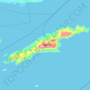
Name: Hydra topographic map, elevation, terrain.
Location: Hydra, Δήμος Ύδρας, Îles, Attique, 180 40, Grèce (37.29297 23.36328 37.37123 23.57944)
Average elevation: 26 m
Minimum elevation: -1 m
Maximum elevation: 582 m
Other topographic maps
Click on a map to view its topography, its elevation and its terrain.