Geolocate

Tropodo topographic map

Click on the map to display elevation.

About this map

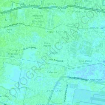
Name: Tropodo topographic map, elevation, terrain.

Location: Tropodo, Waru, Sidoarjo, East Java, Java, 61623, Indonesia (-7.38022 112.73817 -7.34022 112.77817)

Average elevation: 3 m

Minimum elevation: -1 m

Maximum elevation: 7 m

Other topographic maps

Click on a map to view its topography, its elevation and its terrain.

Prambon

Indonesia > East Java > Sidoarjo

Average elevation: 13 m

Krembung

Indonesia > East Java > Sidoarjo

Average elevation: 10 m

Tanggulangin

Indonesia > East Java > Sidoarjo

Average elevation: 3 m

Tulangan

Indonesia > East Java > Sidoarjo

Average elevation: 8 m

Gear up for your next adventure:

🍽️Titanium Camping Spork - Ultralight and indestructible eating utensil
💡LED Camping Lantern - Illuminate your campsite with long-lasting lanterns
🥾Trail Hiking Socks - Comfortable socks to prevent blisters and fatigue
👟Trail Running Shoes - Agile footwear for fast-paced topographic exploration
🎒Hiking Backpack - Lightweight and ergonomic backpacks for day hikes or multi-day treks

As an Amazon Associate, this site earns from qualifying purchases at no extra cost to you.