
Batian topographic map
Interactive map
Click on the map to display elevation.
About this map
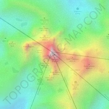
Name: Batian topographic map, elevation, terrain.
Location: Batian, Embu, Ost, Kenia (-0.15276 37.30916 -0.15266 37.30926)
Average elevation: 4,556 m
Minimum elevation: 4,181 m
Maximum elevation: 5,149 m
Der Mount-Kenya-Nationalpark umschließt das zentrale Mount-Kenya-Massiv ab etwa 3200 m Höhe. Zweck des rund 715 km² großen Nationalparks ist es, das Landschaftsbild und die Flora und Fauna zu schützen und für die Zukunft zu bewahren.
Other topographic maps
Click on a map to view its topography, its elevation and its terrain.
Mount Kenya National Park
Mount Kenya National Park, Trail to Nelion Base, Embu, Kenia
Average elevation: 2,561 m