
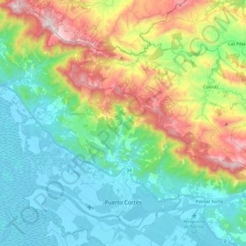
Puerto Cortés topographic map
Interactive map
Click on the map to display elevation.
About this map
Name: Puerto Cortés topographic map, elevation, terrain.
Average elevation: 327 m
Minimum elevation: -2 m
Maximum elevation: 1,092 m
Other topographic maps
Click on a map to view its topography, its elevation and its terrain.
Ojochal
Costa Rica > Cantón Osa > Puerto Cortés
Ojochal, Puerto Cortés, Cantón Osa, Provincia Puntarenas, 60501, Costa Rica
Average elevation: 88 m
Sierpe
Sierpe, Cantón Osa, Provincia Puntarenas, 60503, Costa Rica
Average elevation: 84 m
Playa Hermosa
Costa Rica > Cantón Osa > Bahía Ballena
Playa Hermosa, Bahía Ballena, Cantón Osa, Provincia Puntarenas, 60504, Costa Rica
Average elevation: 137 m
Parque Nacional Marino Ballena
Costa Rica > Cantón Osa > Bahía Ballena
Parque Nacional Marino Ballena, Bahía Ballena, Cantón Osa, Provincia Puntarenas, 60504, Costa Rica
Average elevation: 25 m
Olla 0
Costa Rica > Cantón Osa > Palmar > Olla 0
Olla 0, Palmar, Cantón Osa, Provincia Puntarenas, 60502, Costa Rica
Average elevation: 116 m
Isla del Caño
Costa Rica > Cantón Osa > Bahía Drake
Isla del Caño, Bahía Drake, Cantón Osa, Provincia Puntarenas, 60506, Costa Rica
Average elevation: 22 m
Bahía Ballena
Bahía Ballena, Cantón Osa, Provincia Puntarenas, 60504, Costa Rica
Average elevation: 384 m
Palmar Norte
Costa Rica > Cantón Osa > Palmar > Palmar Norte
Palmar Norte, Palmar, Cantón Osa, Provincia Puntarenas, 60502, Costa Rica
Average elevation: 93 m