
Thank you for supporting this site ❤️
Make a donation
Make a donation
Gear up for your next adventure:
As an Amazon Associate, this site earns from qualifying purchases at no extra cost to you.
Candeiro topographic map
Click on the map to display elevation.
Thank you for supporting this site ❤️
Make a donation
Make a donation
Gear up for your next adventure:
As an Amazon Associate, this site earns from qualifying purchases at no extra cost to you.
About this map
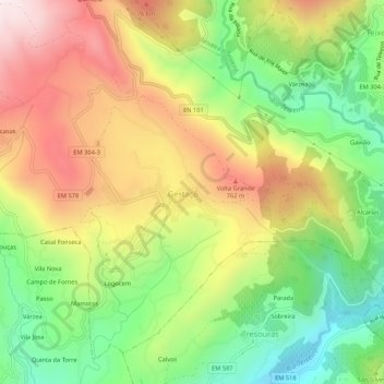
Name: Candeiro topographic map, elevation, terrain.
Location: Candeiro, Gestaçô, Baião, Porto, 4640-233, Portugal (41.14790 -7.94732 41.18790 -7.90732)
Average elevation: 535 m
Minimum elevation: 201 m
Maximum elevation: 916 m
Thank you for supporting this site ❤️
Make a donation
Make a donation
Gear up for your next adventure:
As an Amazon Associate, this site earns from qualifying purchases at no extra cost to you.