Geolocate

Port Washington topographic map

Click on the map to display elevation.

Port Washington

According to the United States Environmental Protection Agency and the United States Geological Survey, the highest point in Port Washington is Beacon Hill, at an elevation of roughly 270 feet (82 m), and the lowest point is Hempstead Harbor and Manhasset Bay, which are at sea level.

Wikipedia (CC-BY-SA 3.0)

About this map

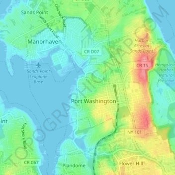
Name: Port Washington topographic map, elevation, terrain.

Location: Port Washington, Town of North Hempstead, Nassau County, New York, United States (40.80498 -73.72182 40.85398 -73.64975)

Average elevation: 21 m

Minimum elevation: -2 m

Maximum elevation: 82 m

Gear up for your next adventure:

🧰Multitool Knife - Compact and versatile tool for outdoor use
💡LED Camping Lantern - Illuminate your campsite with long-lasting lanterns
🛶Kayak Dry Bag - Waterproof storage for kayaking adventures
🎒Fully Waterproof Backpack - Total protection for photography gear and electronics
🧤Thermal Hiking Gloves - Grip-enhanced gloves for cold-weather altitude trekking

As an Amazon Associate, this site earns from qualifying purchases at no extra cost to you.