Geolocate

Pinugay topographic map

Click on the map to display elevation.

About this map

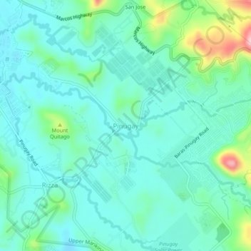
Name: Pinugay topographic map, elevation, terrain.

Location: Pinugay, Baras, Rizal, Calabarzon, Philippines (14.58040 121.26034 14.62040 121.30034)

Average elevation: 218 m

Minimum elevation: 174 m

Maximum elevation: 385 m

Other topographic maps

Click on a map to view its topography, its elevation and its terrain.

Hermosa Ville

Philippines > Rizal > Baras

Average elevation: 52 m

Gear up for your next adventure:

Backpacking Tent - Lightweight tent for long-distance hiking trips
🧤Rechargeable Heated Gloves - Extreme warmth for Canadian winter expeditions
🦟Insect Repellent - Keep mosquitoes and black flies away in wooded areas
🧳Compression Sacks - Maximize space in your backpack by shrinking gear
🧢Outdoor Visor - Breathable visor for sunny hikes

As an Amazon Associate, this site earns from qualifying purchases at no extra cost to you.