
Dalhousie topographic map
Interactive map
Click on the map to display elevation.
Dalhousie
Dalhousie is the most northern point in New Brunswick, and thus is in the Maritime provinces. It is situated in the Restigouche River valley at the tongue of the river where it discharges into Chaleur Bay. The valley lies in a hilly region, part of the Appalachian mountain range, although the Dalhousie town site is situated on a hill side several decameters above sea level with some development to its south on a low ridge of approximately 260 metres elevation. The town is surrounded by salt and fresh water bodies, which are home to many species of wildlife, unique birds, and fish. The area is rich in natural resources.
About this map
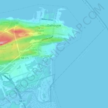
Name: Dalhousie topographic map, elevation, terrain.
Average elevation: 15 m
Minimum elevation: -3 m
Maximum elevation: 191 m
Dalhousie Parish trails, hiking, mountain biking, running and outdoor activities