
Make a donation
Gear up for your next adventure:
As an Amazon Associate, this site earns from qualifying purchases at no extra cost to you.
Mutscheid topographic map
Click on the map to display elevation.
Make a donation
Gear up for your next adventure:
As an Amazon Associate, this site earns from qualifying purchases at no extra cost to you.
Mutscheid
Das Erscheinungsbild der Landschaft ist typisch für die Eifel, mit sanften Hügeln und kleinen Tälern. Sie fällt von einer Höhe von über 510 m ü. NHN an den Hängen des Michelsberges im Nordwesten ab auf unter 300 m im Südosten. Die höchste Erhebung mit 517 m ist die Lausnück in Soller. Bei der Vegetation wechseln sich zusammenhängende Baumbestände mit offenem Wiesenland ab. Ackerbau ist nur noch selten anzutreffen.
Make a donation
Gear up for your next adventure:
As an Amazon Associate, this site earns from qualifying purchases at no extra cost to you.
About this map
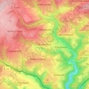
Name: Mutscheid topographic map, elevation, terrain.
Average elevation: 416 m
Minimum elevation: 276 m
Maximum elevation: 512 m
Make a donation
Gear up for your next adventure:
As an Amazon Associate, this site earns from qualifying purchases at no extra cost to you.