
Make a donation
Gear up for your next adventure:
As an Amazon Associate, this site earns from qualifying purchases at no extra cost to you.
Toara topographic map
Click on the map to display elevation.
Make a donation
Gear up for your next adventure:
As an Amazon Associate, this site earns from qualifying purchases at no extra cost to you.
About this map
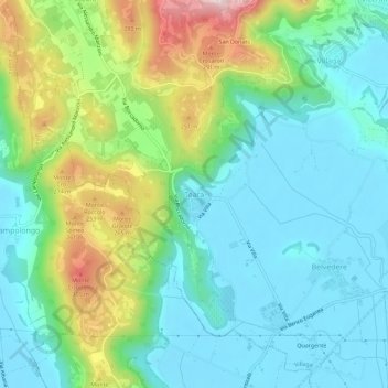
Name: Toara topographic map, elevation, terrain.
Location: Toara, Villaga, Vicenza, Veneto, 36021, Italië (45.36865 11.49393 45.40865 11.53393)
Average elevation: 111 m
Minimum elevation: 12 m
Maximum elevation: 367 m
Make a donation
Gear up for your next adventure:
As an Amazon Associate, this site earns from qualifying purchases at no extra cost to you.
Other topographic maps
Click on a map to view its topography, its elevation and its terrain.
Parco Storico di Villa Guiccioli
Italië > Veneto > Vicenza > Vicenza > Campedello
Average elevation: 54 m
Make a donation
Gear up for your next adventure:
As an Amazon Associate, this site earns from qualifying purchases at no extra cost to you.
Make a donation
Gear up for your next adventure:
As an Amazon Associate, this site earns from qualifying purchases at no extra cost to you.