Geolocate

Paciran topographic map

Click on the map to display elevation.

About this map

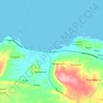
Name: Paciran topographic map, elevation, terrain.

Location: Paciran, Lamongan, East Java, Java, Indonesia (-6.91657 112.35245 -6.83657 112.43245)

Average elevation: 32 m

Minimum elevation: -2 m

Maximum elevation: 153 m

Other topographic maps

Click on a map to view its topography, its elevation and its terrain.

Sidokumpul

Indonesia > East Java > Lamongan > Sambeng

Average elevation: 74 m

Gondang Dam

Indonesia > East Java > Lamongan > Deketagung

Average elevation: 39 m

Lamongan

Indonesia > East Java > Lamongan

Average elevation: 30 m

Gear up for your next adventure:

🥾Mountaineering Boots - Supportive boots for climbing and high-altitude hiking
🪜Heavy Duty Carabiners - Multi-use clips for securing gear to your backpack
🐕Hiking Dog Pack - Let your canine companion carry their own water and food
🥾Hiking Leggings - Comfortable leggings for outdoor activities
🥾Hiking Gaiters - Protect legs and shoes from mud, snow, and debris

As an Amazon Associate, this site earns from qualifying purchases at no extra cost to you.