
Make a donation
Gear up for your next adventure:
As an Amazon Associate, this site earns from qualifying purchases at no extra cost to you.
Wainui topographic map
Click on the map to display elevation.
Make a donation
Gear up for your next adventure:
As an Amazon Associate, this site earns from qualifying purchases at no extra cost to you.
About this map
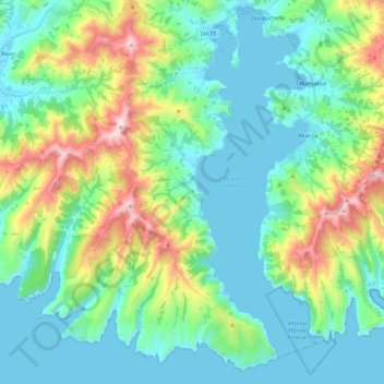
Name: Wainui topographic map, elevation, terrain.
Average elevation: 203 m
Minimum elevation: -1 m
Maximum elevation: 825 m
Make a donation
Gear up for your next adventure:
As an Amazon Associate, this site earns from qualifying purchases at no extra cost to you.
Other topographic maps
Click on a map to view its topography, its elevation and its terrain.
Lyttelton
New Zealand > Canterbury > Christchurch City > Banks Peninsula Community
Average elevation: 99 m
Governors Bay
New Zealand > Canterbury > Christchurch City > Banks Peninsula Community
Average elevation: 167 m
Birdlings Flat
New Zealand > Canterbury > Christchurch City > Banks Peninsula Community
Average elevation: 15 m
Banks Peninsula
New Zealand > Canterbury > Christchurch City > Banks Peninsula Community > Pigeon Bay
Average elevation: 277 m
Make a donation
Gear up for your next adventure:
As an Amazon Associate, this site earns from qualifying purchases at no extra cost to you.
Bossu
New Zealand > Canterbury > Christchurch City > Banks Peninsula Community
Average elevation: 409 m
Ōhinetahi
New Zealand > Canterbury > Christchurch City > Banks Peninsula Community > Governors Bay
Average elevation: 113 m
Giant Totara tree
New Zealand > Canterbury > Christchurch City > Banks Peninsula Community
Average elevation: 382 m
Okuti Valley
New Zealand > Canterbury > Christchurch City > Banks Peninsula Community
Average elevation: 288 m
Make a donation
Gear up for your next adventure:
As an Amazon Associate, this site earns from qualifying purchases at no extra cost to you.
Little River
New Zealand > Canterbury > Christchurch City > Banks Peninsula Community > Little River
Average elevation: 150 m
Little Akaloa
New Zealand > Canterbury > Christchurch City > Banks Peninsula Community
Average elevation: 215 m
Purple Peak Saddle
New Zealand > Canterbury > Christchurch City > Banks Peninsula Community
Average elevation: 479 m