
Make a donation
Gear up for your next adventure:
As an Amazon Associate, this site earns from qualifying purchases at no extra cost to you.
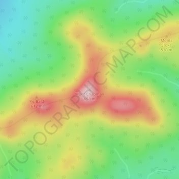
Mont Chapman topographic map
Click on the map to display elevation.
Make a donation
Gear up for your next adventure:
As an Amazon Associate, this site earns from qualifying purchases at no extra cost to you.
Mont Chapman
Le mont Chapman est une montagne s'élevant à 658 mètres d'altitude au pic Bald dans les monts Stoke, dont il est le point culminant, dans les monts Notre-Dame méridionaux. Il est situé à Stoke, au Québec, près de la rivière Saint-François. Il est accessible par des sentiers entretenus par Les Sentiers de l'Estrie. Du sommet, on peut voir le mont Ham, le mont Sainte-Cécile et le mont Mégantic.
Make a donation
Gear up for your next adventure:
As an Amazon Associate, this site earns from qualifying purchases at no extra cost to you.
About this map
Name: Mont Chapman topographic map, elevation, terrain.
Average elevation: 478 m
Minimum elevation: 354 m
Maximum elevation: 636 m
Make a donation
Gear up for your next adventure:
As an Amazon Associate, this site earns from qualifying purchases at no extra cost to you.
Other topographic maps
Click on a map to view its topography, its elevation and its terrain.