
Make a donation
Gear up for your next adventure:
As an Amazon Associate, this site earns from qualifying purchases at no extra cost to you.
Sonntagshorn topographic map
Click on the map to display elevation.
Make a donation
Gear up for your next adventure:
As an Amazon Associate, this site earns from qualifying purchases at no extra cost to you.
Sonntagshorn
Das Sonntagshorn ist der höchste Berg der Chiemgauer Alpen. Er liegt zwischen Ruhpolding und Unken auf der Grenze von Deutschland und Österreich. Seine Höhe wird nach deutscher und österreichischer Messung übereinstimmend mit 1961 m ü. NHN und 1961 m ü. A. angegeben.
Make a donation
Gear up for your next adventure:
As an Amazon Associate, this site earns from qualifying purchases at no extra cost to you.
About this map
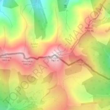
Name: Sonntagshorn topographic map, elevation, terrain.
Average elevation: 1,476 m
Minimum elevation: 945 m
Maximum elevation: 1,928 m
Make a donation
Gear up for your next adventure:
As an Amazon Associate, this site earns from qualifying purchases at no extra cost to you.