Geolocate

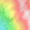
Le Mollard topographic map

Click on the map to display elevation.

About this map

Name: Le Mollard topographic map, elevation, terrain.

Location: Le Mollard, Beaune, Saint-Michel-de-Maurienne, Saint-Jean-de-Maurienne, Savoie, Auvergne-Rhône-Alpes, France métropolitaine, 73140, France (45.22969 6.44610 45.26969 6.48610)

Average elevation: 1,419 m

Minimum elevation: 676 m

Maximum elevation: 2,461 m

Other topographic maps

Click on a map to view its topography, its elevation and its terrain.
Gear up for your next adventure:

🧢Outdoor Cap - Protective cap for sun and rain during hikes
🥾Mountaineering Boots - Supportive boots for climbing and high-altitude hiking
🧰Emergency Multi-Tool - Compact multi-tool for outdoor survival
🌬️Windproof Camp Stove - Efficient cooking even on exposed mountain peaks
🚲Bike Repair Kit - Essential tools for on-trail mechanical issues

As an Amazon Associate, this site earns from qualifying purchases at no extra cost to you.