
Make a donation
Gear up for your next adventure:
As an Amazon Associate, this site earns from qualifying purchases at no extra cost to you.
Bunker Hill topographic map
Click on the map to display elevation.
Make a donation
Gear up for your next adventure:
As an Amazon Associate, this site earns from qualifying purchases at no extra cost to you.
Bunker Hill
Bunker Hill is located at 38°52′29″N 98°42′10″W / 38.87472°N 98.70278°W / 38.87472; -98.70278 (38.874716, -98.702759), at an elevation of 1,860 feet (567 m). Located in north-central Kansas, Bunker Hill is 108 miles (174 km) northwest of Wichita and 221 miles (355 km) west of Kansas City. Located 1 mile (1.7 km) north of Interstate 70, it is roughly 8 miles (13 km) east of Russell, the county seat.
Make a donation
Gear up for your next adventure:
As an Amazon Associate, this site earns from qualifying purchases at no extra cost to you.
About this map
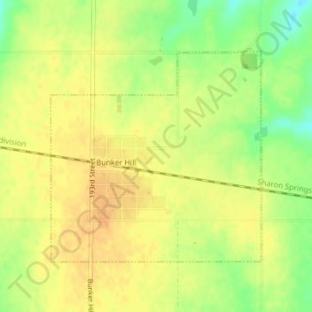
Name: Bunker Hill topographic map, elevation, terrain.
Location: Bunker Hill, Russell County, Kansas, United States (38.86724 -98.71125 38.88547 -98.68782)
Average elevation: 562 m
Minimum elevation: 541 m
Maximum elevation: 573 m
Make a donation
Gear up for your next adventure:
As an Amazon Associate, this site earns from qualifying purchases at no extra cost to you.