Geolocate

Piangiacolin topographic map

Click on the map to display elevation.

About this map

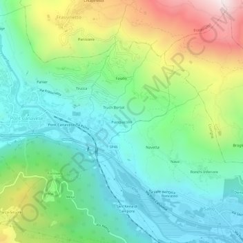
Name: Piangiacolin topographic map, elevation, terrain.

Location: Piangiacolin, Pont Canavese, Torino, Piemonte, 10085, Italia (45.39990 7.59913 45.43990 7.63913)

Average elevation: 747 m

Minimum elevation: 388 m

Maximum elevation: 1,536 m

Gear up for your next adventure:

🔨Vehicle Emergency Tool - Safety tool for remote road trips to trailheads
🍽️Titanium Camping Spork - Ultralight and indestructible eating utensil
🕶️Polarized Sunglasses - Protect your eyes with durable polarized lenses
🏕️Camping Hammock - Integrated protection for sleeping between trees
🦯Trekking Poles - Reduced impact on joints for steep topographic climbs

As an Amazon Associate, this site earns from qualifying purchases at no extra cost to you.