Geolocate

San Isidro topographic map

Click on the map to display elevation.

About this map

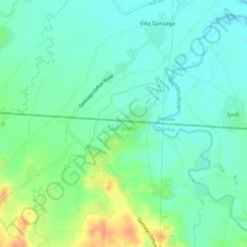
Name: San Isidro topographic map, elevation, terrain.

Location: San Isidro, Santiago, Quirino, Cagayan Valley, Philippines (16.61935 121.48839 16.65935 121.52839)

Average elevation: 101 m

Minimum elevation: 87 m

Maximum elevation: 130 m

Gear up for your next adventure:

🧥Fleece Jacket - Warm and lightweight jacket for layering
🔦LED Headtorch - Bright and durable light for night activities
🧣Merino Neck Gaiter - Protects against wind, sun, and cold at high altitudes
🥾Trail Running Shoes - Lightweight and durable shoes for trail running
🪜Heavy Duty Carabiners - Multi-use clips for securing gear to your backpack

As an Amazon Associate, this site earns from qualifying purchases at no extra cost to you.