
Make a donation
Gear up for your next adventure:
As an Amazon Associate, this site earns from qualifying purchases at no extra cost to you.
Alomartes topographic map
Click on the map to display elevation.
Make a donation
Gear up for your next adventure:
As an Amazon Associate, this site earns from qualifying purchases at no extra cost to you.
Alomartes
Alomartes ist eine Ortschaft in der Provinz Granada in der autonomen Region Andalusien. Sie liegt am Fuße der Sierra Parapanda auf 700 Metern Höhe. Die Ortschaft ist der größte Ortsteil der Gemeinde Íllora und hat mehr als 2000 Einwohner.
Make a donation
Gear up for your next adventure:
As an Amazon Associate, this site earns from qualifying purchases at no extra cost to you.
About this map
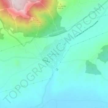
Name: Alomartes topographic map, elevation, terrain.
Average elevation: 763 m
Minimum elevation: 600 m
Maximum elevation: 1,358 m
Make a donation
Gear up for your next adventure:
As an Amazon Associate, this site earns from qualifying purchases at no extra cost to you.