
Thank you for supporting this site ❤️
Make a donation
Make a donation
Gear up for your next adventure:
As an Amazon Associate, this site earns from qualifying purchases at no extra cost to you.
Sefaköy topographic map
Click on the map to display elevation.
Thank you for supporting this site ❤️
Make a donation
Make a donation
Gear up for your next adventure:
As an Amazon Associate, this site earns from qualifying purchases at no extra cost to you.
About this map
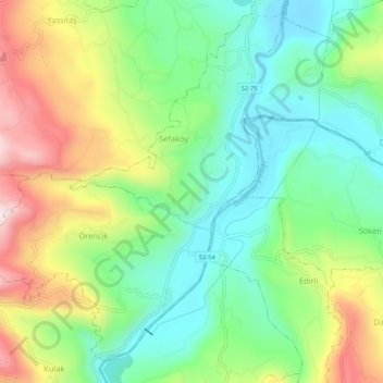
Name: Sefaköy topographic map, elevation, terrain.
Location: Sefaköy, Fatsa, Ordu, Black Sea Region, Turkey (40.93211 37.47659 40.97211 37.51659)
Average elevation: 188 m
Minimum elevation: 31 m
Maximum elevation: 453 m
Thank you for supporting this site ❤️
Make a donation
Make a donation
Gear up for your next adventure:
As an Amazon Associate, this site earns from qualifying purchases at no extra cost to you.