
Make a donation
Gear up for your next adventure:
As an Amazon Associate, this site earns from qualifying purchases at no extra cost to you.
Landwüst topographic map
Click on the map to display elevation.
Make a donation
Gear up for your next adventure:
As an Amazon Associate, this site earns from qualifying purchases at no extra cost to you.
Landwüst
Das Waldhufendorf Landwüst liegt im Süden des sächsischen Teils des historischen Vogtlands bzw. Oberen Vogtlands, am Nordwesthang des Wirtsberges (664 m) im Elstergebirge in einer Höhe zwischen 570 m und 640 m. Die Grenze zu Tschechien ist im Südosten nur knapp zwei Kilometer von Landwüst entfernt. Ehemalige Ortsteile, jetzt Wüstungen, sind Tockengrün und Winthersreuth.
Make a donation
Gear up for your next adventure:
As an Amazon Associate, this site earns from qualifying purchases at no extra cost to you.
About this map
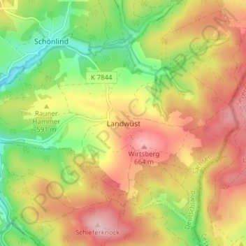
Name: Landwüst topographic map, elevation, terrain.
Average elevation: 585 m
Minimum elevation: 494 m
Maximum elevation: 669 m
Make a donation
Gear up for your next adventure:
As an Amazon Associate, this site earns from qualifying purchases at no extra cost to you.