
Make a donation
Gear up for your next adventure:
As an Amazon Associate, this site earns from qualifying purchases at no extra cost to you.
Assenede topographic map
Click on the map to display elevation.
Make a donation
Gear up for your next adventure:
As an Amazon Associate, this site earns from qualifying purchases at no extra cost to you.
Assenede
Assenede ligt op de rand van het Vlaamse poldergebied en Zandig Vlaanderen. De hoogte bedraagt 2-5 meter. Ten noorden van Assenede ligt een krekengebied met kreken als: Grote Geul, Rode Geul, Grote Kil, Kleine Kil, een wiel (de Verzeleput en Bodemloze Put) en waterlopen, waarvan de Vlietbeek de belangrijkste is.
Make a donation
Gear up for your next adventure:
As an Amazon Associate, this site earns from qualifying purchases at no extra cost to you.
About this map
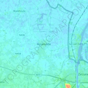
Name: Assenede topographic map, elevation, terrain.
Location: Assenede, Eeklo, Oost-Vlaanderen, Vlaanderen, 9960, België (51.18759 3.71329 51.26759 3.79329)
Average elevation: 3 m
Minimum elevation: -6 m
Maximum elevation: 46 m
Make a donation
Gear up for your next adventure:
As an Amazon Associate, this site earns from qualifying purchases at no extra cost to you.