Geolocate

Mulbarton topographic map

Click on the map to display elevation.

About this map

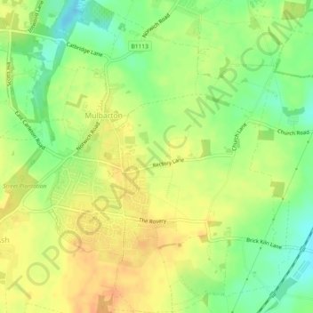
Name: Mulbarton topographic map, elevation, terrain.

Location: Mulbarton, South Norfolk, Norfolk, England, United Kingdom (52.54658 1.22306 52.57439 1.26183)

Average elevation: 41 m

Minimum elevation: 21 m

Maximum elevation: 55 m

Other topographic maps

Click on a map to view its topography, its elevation and its terrain.

Keswick

United Kingdom > England > Norfolk > South Norfolk

Average elevation: 23 m

Gear up for your next adventure:

🧤Insulated Winter Gloves - Heavy-duty protection for sub-zero Canadian adventures
🧦Merino Wool Socks - Moisture-wicking comfort for long-distance hiking
🧴Outdoor Sunscreen - High SPF protection for high-altitude UV exposure
🔭Outdoor Binoculars - Lightweight binoculars for birdwatching and hiking
💧Reusable Water Bottle - Durable water bottles for hydration on trails

As an Amazon Associate, this site earns from qualifying purchases at no extra cost to you.