
Thank you for supporting this site ❤️
Make a donation
Make a donation
Gear up for your next adventure:
As an Amazon Associate, this site earns from qualifying purchases at no extra cost to you.
Philipsburg topographic map
Click on the map to display elevation.
Thank you for supporting this site ❤️
Make a donation
Make a donation
Gear up for your next adventure:
As an Amazon Associate, this site earns from qualifying purchases at no extra cost to you.
About this map
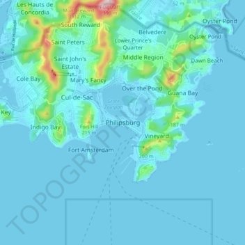
Name: Philipsburg topographic map, elevation, terrain.
Location: Philipsburg, Country of Sint Maarten, 721, Netherlands (17.98507 -63.08831 18.06507 -63.00831)
Average elevation: 33 m
Minimum elevation: -4 m
Maximum elevation: 377 m
Thank you for supporting this site ❤️
Make a donation
Make a donation
Gear up for your next adventure:
As an Amazon Associate, this site earns from qualifying purchases at no extra cost to you.