
Make a donation
Gear up for your next adventure:
As an Amazon Associate, this site earns from qualifying purchases at no extra cost to you.
Wippenbach topographic map
Click on the map to display elevation.
Make a donation
Gear up for your next adventure:
As an Amazon Associate, this site earns from qualifying purchases at no extra cost to you.
Wippenbach
Wippenbach liegt westlich direkt anschließend an den Ortskern von Ortenberg auf einer Höhe von 195 m ü. NN, westlich von Ortenberg an der Nidder, 6,5 km südöstlich von Nidda. Durch den Ort führt die Landesstraße 3184.
Make a donation
Gear up for your next adventure:
As an Amazon Associate, this site earns from qualifying purchases at no extra cost to you.
About this map
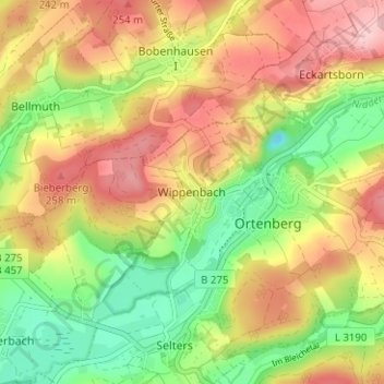
Name: Wippenbach topographic map, elevation, terrain.
Location: Wippenbach, Ortenberg, Wetteraukreis, Hessen, 63683, Deutschland (50.33686 9.02052 50.37686 9.06052)
Average elevation: 193 m
Minimum elevation: 101 m
Maximum elevation: 288 m
Make a donation
Gear up for your next adventure:
As an Amazon Associate, this site earns from qualifying purchases at no extra cost to you.