Geolocate

Hongjiang topographic map

Click on the map to display elevation.

About this map

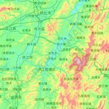
Name: Hongjiang topographic map, elevation, terrain.

Location: Hongjiang, Huaihua, Hunan, China (26.98937 109.53253 27.47921 110.52207)

Average elevation: 494 m

Minimum elevation: 132 m

Maximum elevation: 1,918 m

Gear up for your next adventure:

Camping Groundsheet - Protect your tent from moisture and dirt
🧦Outdoor Socks - Durable socks designed for hiking and outdoor sports
🔪Outdoor Multitool - Versatile tool for repairs and food prep in the wild
🥾Hiking Shoes - Durable and comfortable shoes for trail hiking
🧥Softshell Hiking Jacket - The perfect balance of wind protection and breathability

As an Amazon Associate, this site earns from qualifying purchases at no extra cost to you.