Geolocate

Torgau topographic map

Click on the map to display elevation.

About this map

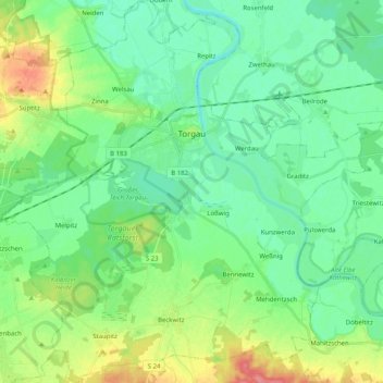
Name: Torgau topographic map, elevation, terrain.

Location: Torgau, Nordsachsen, Saxony, Germany (51.47584 12.90578 51.60189 13.10587)

Average elevation: 92 m

Minimum elevation: 72 m

Maximum elevation: 143 m

Other topographic maps

Click on a map to view its topography, its elevation and its terrain.

Melpitz

Germany > Saxony > Nordsachsen > Torgau

Average elevation: 89 m

Podelwitz

Germany > Saxony > Nordsachsen

Average elevation: 126 m

Kathewitz

Germany > Saxony > Nordsachsen

Average elevation: 86 m

Kathewitz

Germany > Saxony > Nordsachsen

Average elevation: 86 m

Wehlitz

Germany > Saxony > Nordsachsen > Schkeuditz

Average elevation: 110 m

Spielburg

Germany > Saxony > Nordsachsen > Eilenburg

Average elevation: 104 m

Gear up for your next adventure:

🧶550 Survival Paracord - Versatile utility cord for emergency repairs and rigging
🥾Approach Shoes - Shoes designed for climbing approaches and rugged trails
🧢Sun Hat - Wide-brim hat for sun protection
🔨Vehicle Emergency Tool - Safety tool for remote road trips to trailheads
🔋Solar Power Bank - Keep your GPS and devices charged during long outdoor trips

As an Amazon Associate, this site earns from qualifying purchases at no extra cost to you.