
Make a donation
Gear up for your next adventure:
As an Amazon Associate, this site earns from qualifying purchases at no extra cost to you.
San Juan Comalapa topographic map
Click on the map to display elevation.
Make a donation
Gear up for your next adventure:
As an Amazon Associate, this site earns from qualifying purchases at no extra cost to you.
About this map
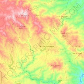
Name: San Juan Comalapa topographic map, elevation, terrain.
Location: San Juan Comalapa, Chimaltenango, Guatemala (14.69002 -90.93923 14.80188 -90.83919)
Average elevation: 2,106 m
Minimum elevation: 1,659 m
Maximum elevation: 2,507 m
Make a donation
Gear up for your next adventure:
As an Amazon Associate, this site earns from qualifying purchases at no extra cost to you.
Other topographic maps
Click on a map to view its topography, its elevation and its terrain.
Bosque San Antionio
Guatemala > Chimaltenango > San Juan Comalapa > San Juan Comalapa
Average elevation: 2,125 m
Make a donation
Gear up for your next adventure:
As an Amazon Associate, this site earns from qualifying purchases at no extra cost to you.
Bosque San Antionio
Guatemala > Chimaltenango > San Juan Comalapa > San Juan Comalapa
Average elevation: 2,125 m