Geolocate

Keeling topographic map

Click on the map to display elevation.

About this map

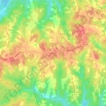
Name: Keeling topographic map, elevation, terrain.

Location: Keeling, Pittsylvania County, Virginia, 24566, United States (36.70014 -79.30835 36.74014 -79.26835)

Average elevation: 195 m

Minimum elevation: 156 m

Maximum elevation: 225 m

Other topographic maps

Click on a map to view its topography, its elevation and its terrain.

Gretna

United States > Virginia > Pittsylvania County

Average elevation: 253 m

Hurt

United States > Virginia > Pittsylvania County

Average elevation: 194 m

Gretna

United States > Virginia > Pittsylvania County

Average elevation: 253 m

Chatham

United States > Virginia > Pittsylvania County

Average elevation: 209 m

Chatham

United States > Virginia > Pittsylvania County

Average elevation: 209 m

Gear up for your next adventure:

🛏️Camping Sleeping Mat - Comfortable mats for sleeping outdoors
🌡️Emergency Mylar Blankets - Compact thermal protection for unexpected nights outdoors
🔋Emergency Crank Radio - Weather alerts and power without needing batteries
🚲MTB Frame Bag - Carry tools and maps directly on your bicycle frame
🔭Outdoor Binoculars - Lightweight binoculars for birdwatching and hiking

As an Amazon Associate, this site earns from qualifying purchases at no extra cost to you.