
Make a donation
Gear up for your next adventure:
As an Amazon Associate, this site earns from qualifying purchases at no extra cost to you.
Ibb topographic map
Click on the map to display elevation.
Make a donation
Gear up for your next adventure:
As an Amazon Associate, this site earns from qualifying purchases at no extra cost to you.
Ibb
Ibb is located at an altitude of 2,050 metres (6,730 ft) on a spur of Mount Shamāḥī. Due to its high altitude, Ibb has a dry-winter humid subtropical climate (Köppen climate classification: Cwa), and is one of the wettest areas of Yemen, typically receiving around 500 mm of rain per annum.
Make a donation
Gear up for your next adventure:
As an Amazon Associate, this site earns from qualifying purchases at no extra cost to you.
About this map
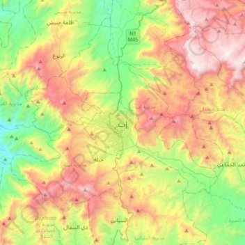
Name: Ibb topographic map, elevation, terrain.
Location: Ibb, Al Dhihar District, Ibb Governorate, Yemen (13.81016 44.01794 14.13016 44.33794)
Average elevation: 2,104 m
Minimum elevation: 1,249 m
Maximum elevation: 3,235 m
Make a donation
Gear up for your next adventure:
As an Amazon Associate, this site earns from qualifying purchases at no extra cost to you.
Other topographic maps
Click on a map to view its topography, its elevation and its terrain.
Make a donation
Gear up for your next adventure:
As an Amazon Associate, this site earns from qualifying purchases at no extra cost to you.