
Make a donation
Gear up for your next adventure:
As an Amazon Associate, this site earns from qualifying purchases at no extra cost to you.
Alappuzha topographic map
Click on the map to display elevation.
Make a donation
Gear up for your next adventure:
As an Amazon Associate, this site earns from qualifying purchases at no extra cost to you.
Alappuzha
Alappuzha is located at 9°32′N 76°24′E / 9.54°N 76.40°E / 9.54; 76.40. The average elevation is 1 metre (3.3 ft). Alappuzha covers an area of 1,414 square kilometres (546 sq mi) and is flanked by 2,195 square kilometres (847 sq mi) of Vembanad Lake, where six major rivers spread out before joining the 80 km coast line of the district. The city of Alappuzha is crisscrossed by a system of canals, which is a part of the National Waterway 3.
Make a donation
Gear up for your next adventure:
As an Amazon Associate, this site earns from qualifying purchases at no extra cost to you.
About this map
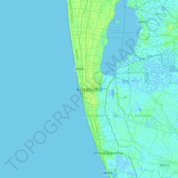
Name: Alappuzha topographic map, elevation, terrain.
Average elevation: 2 m
Minimum elevation: -6 m
Maximum elevation: 22 m
Make a donation
Gear up for your next adventure:
As an Amazon Associate, this site earns from qualifying purchases at no extra cost to you.