
McLean County topographic map
Interactive map
Click on the map to display elevation.
About this map
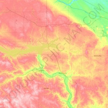
Name: McLean County topographic map, elevation, terrain.
Location: McLean County, North Dakota, United States (47.15790 -102.38651 47.84948 -100.58461)
Average elevation: 596 m
Minimum elevation: 456 m
Maximum elevation: 743 m
Other topographic maps
Click on a map to view its topography, its elevation and its terrain.
Turtle Lake
United States > North Dakota > McLean County
Turtle Lake, McLean County, North Dakota, United States
Average elevation: 572 m