Geolocate

Poplar topographic map

Click on the map to display elevation.

About this map

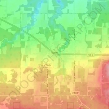
Name: Poplar topographic map, elevation, terrain.

Location: Poplar, Douglas County, Wisconsin, 54864, United States (46.56091 -91.82560 46.60467 -91.74170)

Average elevation: 305 m

Minimum elevation: 251 m

Maximum elevation: 364 m

Other topographic maps

Click on a map to view its topography, its elevation and its terrain.

Dairyland

United States > Wisconsin > Douglas County

Average elevation: 339 m

Hawthorne

United States > Wisconsin > Douglas County

Average elevation: 357 m

South Range

United States > Wisconsin > Douglas County

Average elevation: 237 m

Bennett

United States > Wisconsin > Douglas County

Average elevation: 368 m

Foxboro

United States > Wisconsin > Douglas County

Average elevation: 277 m

Gear up for your next adventure:

🧴Waterproofing Spray - Restore the DWR coating on jackets and tents
🦶Hiking Shoe Insoles - Added support for high arches and long days on feet
🥾Lightweight Hiking Boots - Boots for comfort and mobility on long hikes
Backpacking Tent - Lightweight tent for long-distance hiking trips
💧Hydration Bladder - Hands-free hydration solution for long treks

As an Amazon Associate, this site earns from qualifying purchases at no extra cost to you.