
Thank you for supporting this site ❤️
Make a donation
Make a donation
Gear up for your next adventure:
As an Amazon Associate, this site earns from qualifying purchases at no extra cost to you.
Ohlsdorf topographic map
Click on the map to display elevation.
Thank you for supporting this site ❤️
Make a donation
Make a donation
Gear up for your next adventure:
As an Amazon Associate, this site earns from qualifying purchases at no extra cost to you.
About this map
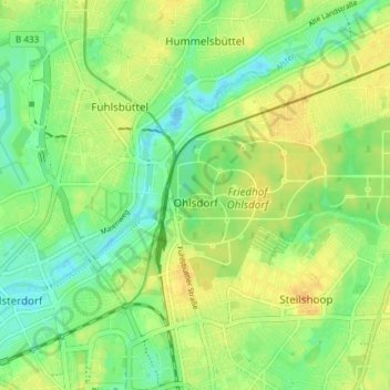
Name: Ohlsdorf topographic map, elevation, terrain.
Location: Ohlsdorf, Hamburg-Nord, Hamburg, 22337, Deutschland (53.60654 10.01129 53.63820 10.08521)
Average elevation: 20 m
Minimum elevation: 5 m
Maximum elevation: 34 m
Thank you for supporting this site ❤️
Make a donation
Make a donation
Gear up for your next adventure:
As an Amazon Associate, this site earns from qualifying purchases at no extra cost to you.