Make a donation
Gear up for your next adventure:
As an Amazon Associate, this site earns from qualifying purchases at no extra cost to you.
Uxbridge topographic map
Click on the map to display elevation.
Make a donation
Gear up for your next adventure:
As an Amazon Associate, this site earns from qualifying purchases at no extra cost to you.
Uxbridge
Uxbridge lies at a mean elevation of 130 feet (40 m) above mean sea level. Like much of the rest of the UK its climate is generally temperate, with few extremes of temperature or weather.
Make a donation
Gear up for your next adventure:
As an Amazon Associate, this site earns from qualifying purchases at no extra cost to you.
About this map
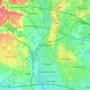
Name: Uxbridge topographic map, elevation, terrain.
Location: Uxbridge, Greater London, England, UB8 1SB, United Kingdom (51.50495 -0.52167 51.58495 -0.44167)
Average elevation: 44 m
Minimum elevation: 23 m
Maximum elevation: 89 m
Make a donation
Gear up for your next adventure:
As an Amazon Associate, this site earns from qualifying purchases at no extra cost to you.
Other topographic maps
Click on a map to view its topography, its elevation and its terrain.
Sheffield
Sheffield nestles on the eastern foothills of the Pennines and is sculpted by a dramatic hill-and-valley system formed where five rivers — the Don, Sheaf, Rivelin, Loxley and Porter — converge, producing steep-sided valleys and gritstone ridgelines with much of the urban area built directly onto hillsides…
Average elevation: 168 m
Make a donation
Gear up for your next adventure:
As an Amazon Associate, this site earns from qualifying purchases at no extra cost to you.
Suffolk
The west of the county lies on more resistant Cretaceous chalk. This chalk is responsible for a sweeping tract of largely downland landscapes that stretches from Dorset in the south west to Dover in the south east and north through East Anglia to the Yorkshire Wolds. The chalk is less easily eroded so forms…
Average elevation: 35 m
East of England
The East of England region has the lowest elevation range in the UK. Twenty percent of the region is below mean sea level, most of this in North Cambridgeshire, Norfolk and on the Essex Coast. Most of the remaining area is of low elevation, with extensive glacial deposits. The Fens, a large area of reclaimed…
Average elevation: 39 m
Kent
Kent was also the location of the largest number of art schools in the country during the nineteenth century, estimated by the art historian David Haste, to approach two hundred. This is believed to be the result of Kent being a front line county during the Napoleonic Wars. At this time, before the invention…
Average elevation: 37 m
Make a donation
Gear up for your next adventure:
As an Amazon Associate, this site earns from qualifying purchases at no extra cost to you.
Somerset
Many settlements developed because of their strategic importance in relation to geographical features, such as river crossings or valleys in ranges of hills. Examples include Axbridge on the River Axe, Castle Cary on the River Cary, North Petherton on the River Parrett, and Ilminster, where there was a…
Average elevation: 96 m
Make a donation
Gear up for your next adventure:
As an Amazon Associate, this site earns from qualifying purchases at no extra cost to you.
Cambridge
United Kingdom > England > Cambridge
The city, like most of the UK, has a maritime climate highly influenced by the Gulf Stream. Located in the driest region of Britain, Cambridge's rainfall averages around 570 mm (22.44 in) per year, around half the national average, with some years occasionally falling into the semi-arid (under 500 mm (19.69…
Average elevation: 18 m
Greater London
London's topography is characterized by a gently rolling terrain shaped by the River Thames and its tributaries. The city lies within the London Basin, a natural depression bordered by higher grounds such as the North Downs to the south and the Chiltern Hills to the northwest. The Thames flows west to east,…
Average elevation: 66 m
Make a donation
Gear up for your next adventure:
As an Amazon Associate, this site earns from qualifying purchases at no extra cost to you.
Cornwall
The interior of the county consists of a roughly east–west spine of infertile and exposed upland, with a series of granite intrusions, such as Bodmin Moor, which contains the highest land within Cornwall. From east to west, and with approximately descending altitude, these are Bodmin Moor, Hensbarrow north…
Average elevation: 55 m
Make a donation
Gear up for your next adventure:
As an Amazon Associate, this site earns from qualifying purchases at no extra cost to you.
South East England
Near Weybridge are the UK headquarters of Sony with SSP Group (situated in Byfleet) and Procter & Gamble (next door to each other on The Heights Business Park near the former Brooklands racing circuit) with Kia Motors UK and Petroleum Geo-Services UK, and Gallaher Group (cigarettes) is to the north, next to…
Average elevation: 69 m
Ipswich
United Kingdom > England > Suffolk
Ipswich experiences an oceanic climate, like the rest of the British Isles, with a narrow range of temperature and rainfall spread evenly throughout the year. One of the two nearest for which data is available is East Bergholt, about 7 miles (11 km) south west of the town centre and at a similar elevation, and…
Average elevation: 29 m
Make a donation
Gear up for your next adventure:
As an Amazon Associate, this site earns from qualifying purchases at no extra cost to you.
Castle Donington
United Kingdom > England > Leicestershire > North West Leicestershire > Hemington
Average elevation: 56 m
Reading
Jane Austen attended Reading Ladies Boarding School, based in the Abbey Gateway, in 1784–1786. Mary Russell Mitford lived in Reading for a number of years and then spent the rest of her life just outside the town at Three Mile Cross and Swallowfield. The fictional Belford Regis of her eponymous novel, first…
Average elevation: 54 m
Make a donation
Gear up for your next adventure:
As an Amazon Associate, this site earns from qualifying purchases at no extra cost to you.
Bath
United Kingdom > England > Bath and North East Somerset
Bath is in the Avon Valley and is surrounded by limestone hills as it is near the southern edge of the Cotswolds, a designated Area of Outstanding Natural Beauty, and the limestone Mendip Hills rise around 7 miles (11 km) south of the city. The hills that surround and make up the city have a maximum altitude…
Average elevation: 100 m
Make a donation
Gear up for your next adventure:
As an Amazon Associate, this site earns from qualifying purchases at no extra cost to you.
Lake District National Park
The Lake District is a roughly circular upland massif, deeply dissected by a broadly radial pattern of major valleys which are largely the result of repeated glaciations over the last 2 million years. The apparent radial pattern is not from a central dome, but from an axial watershed extending from St Bees…
Average elevation: 206 m
Derbyshire
Due to its central location in England and altitude range from 27 metres in the south to 636 metres in the north, Derbyshire contains many species at the edge of their UK distribution ranges. Some species with a predominantly northern British distribution are at the southern limit of their range, whilst others…
Average elevation: 144 m
South Downs National Park
United Kingdom > England > West Sussex
The South Downs National Park's chalk downland is a feature that sets it apart from other national parks in Britain. However, almost a quarter (23%) of the national park consists of a quite different and strongly contrasting physiographic region, the western Weald, whose densely wooded hills and vales are…
Average elevation: 54 m
Birmingham
Birmingham is a snowy city relative to other large UK conurbations, due to its inland location and comparatively high elevation. Between 1961 and 1990 Birmingham Airport averaged 13.0 days of snow lying annually, compared to 5.33 at London Heathrow. Snow showers often pass through the city via the Cheshire gap…
Average elevation: 138 m
Make a donation
Gear up for your next adventure:
As an Amazon Associate, this site earns from qualifying purchases at no extra cost to you.
Make a donation
Gear up for your next adventure:
As an Amazon Associate, this site earns from qualifying purchases at no extra cost to you.
Make a donation
Gear up for your next adventure:
As an Amazon Associate, this site earns from qualifying purchases at no extra cost to you.
River Severn
The River Severn (Welsh: Afon Hafren, pronounced [ˈavɔn ˈhavrɛn]), at 220 miles (354 km) long, is the longest river in Great Britain. It is also the river with the most voluminous flow of water by far in all of England and Wales, with an average flow rate of 107 m3/s (3,800 cu ft/s) at Apperley,…
Average elevation: 169 m
Make a donation
Gear up for your next adventure:
As an Amazon Associate, this site earns from qualifying purchases at no extra cost to you.
Leicestershire
A large part of the north-west of the county, around Coalville, forms part of the new National Forest area extending into Derbyshire and Staffordshire. The highest point of the county is Bardon Hill at 278 m (912 ft), which is also a Marilyn; with other hilly/upland areas of around 150–200 metres (490–660…
Average elevation: 97 m
Make a donation
Gear up for your next adventure:
As an Amazon Associate, this site earns from qualifying purchases at no extra cost to you.
Lyme Regis
United Kingdom > England > Dorset
Lyme Regis is a coastal town in West Dorset, 25 miles (40 km) west of Dorchester and 25 miles (40 km) east of Exeter. It lies in Lyme Bay, on the English Channel coast at the Dorset–Devon border. At the 2011 census, it had a population of 3,671. The town has grown around the mouth of the River Lim (or Lym)…
Average elevation: 83 m
Make a donation
Gear up for your next adventure:
As an Amazon Associate, this site earns from qualifying purchases at no extra cost to you.
Make a donation
Gear up for your next adventure:
As an Amazon Associate, this site earns from qualifying purchases at no extra cost to you.
Make a donation
Gear up for your next adventure:
As an Amazon Associate, this site earns from qualifying purchases at no extra cost to you.
Northampton
United Kingdom > England > West Northamptonshire > Northampton
As with the rest of the British Isles, Northampton experiences a maritime climate with cool summers and mild winters. The official Met Office weather station for Northampton is the Moulton Park Weather Station at the University of Northampton. Situated at an elevation of around 130 m (427 ft) above sea level…
Average elevation: 89 m
Make a donation
Gear up for your next adventure:
As an Amazon Associate, this site earns from qualifying purchases at no extra cost to you.
Skegness
United Kingdom > England > Lincolnshire > East Lindsey
Skegness fronts the North Sea. It is located on a low-lying flat region called Lincoln Marsh, which runs along the coast between Skegness and the Humber and separates the coast from the upland Wolds. Much of the parish's elevation is close to sea level, although a narrow band along the seafront is 4–5 m…
Average elevation: 2 m
Yorkshire and the Humber
In the Yorkshire and the Humber region, there is a very close relationship between the major topographical areas and the underlying geology. The Pennine chain of hills in the west is of Carboniferous origin. The central vale is Permo-Triassic. The North York Moors in the north-east of the region are Jurassic…
Average elevation: 120 m
Make a donation
Gear up for your next adventure:
As an Amazon Associate, this site earns from qualifying purchases at no extra cost to you.
Make a donation
Gear up for your next adventure:
As an Amazon Associate, this site earns from qualifying purchases at no extra cost to you.
Farnham
United Kingdom > England > Surrey > Waverley
Farnham lies in the valley of the North Branch of the River Wey, which rises near Alton, merges with the South Branch at Tilford, and joins the River Thames at Weybridge. The mainly east-west alignment of the ridges and valleys has influenced the development of road and rail communications. The most prominent…
Average elevation: 100 m
Make a donation
Gear up for your next adventure:
As an Amazon Associate, this site earns from qualifying purchases at no extra cost to you.
Make a donation
Gear up for your next adventure:
As an Amazon Associate, this site earns from qualifying purchases at no extra cost to you.
Cottenham
United Kingdom > England > Cambridgeshire > South Cambridgeshire > Cottenham
Average elevation: 5 m
Make a donation
Gear up for your next adventure:
As an Amazon Associate, this site earns from qualifying purchases at no extra cost to you.
Make a donation
Gear up for your next adventure:
As an Amazon Associate, this site earns from qualifying purchases at no extra cost to you.
Make a donation
Gear up for your next adventure:
As an Amazon Associate, this site earns from qualifying purchases at no extra cost to you.
Todmorden
United Kingdom > England > Calderdale > Lydgate
Todmorden Town Hall, which was designed in the Neo-Classical style, dominates the centre of the town. The building straddles the Walsden Water, a tributary of the River Calder, and was situated in both Lancashire and Yorkshire until the administrative county boundary was moved on 1 January 1888. Designed by…
Average elevation: 311 m
Make a donation
Gear up for your next adventure:
As an Amazon Associate, this site earns from qualifying purchases at no extra cost to you.
