
Make a donation
Gear up for your next adventure:
As an Amazon Associate, this site earns from qualifying purchases at no extra cost to you.
Berninapass topographic map
Click on the map to display elevation.
Make a donation
Gear up for your next adventure:
As an Amazon Associate, this site earns from qualifying purchases at no extra cost to you.
Berninapass
The building of the road began in 1842. Head of engineers was Rudolf Albertini (1821–1896) from Zuoz. The work was finished in 1865 and a hospice at an elevation of 2,307 metres (7,569 ft) was also opened. Since this time the road has been widened several times. Since 1965 it has been open all year round, although there is snow during 8 months.
Make a donation
Gear up for your next adventure:
As an Amazon Associate, this site earns from qualifying purchases at no extra cost to you.
About this map
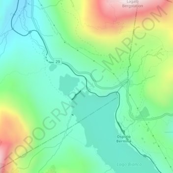
Name: Berninapass topographic map, elevation, terrain.
Location: Berninapass, Pontresina, Maloja, Grisons, 7504, Switzerland (46.41573 10.01143 46.41583 10.01153)
Average elevation: 2,351 m
Minimum elevation: 2,122 m
Maximum elevation: 2,867 m
Make a donation
Gear up for your next adventure:
As an Amazon Associate, this site earns from qualifying purchases at no extra cost to you.