Geolocate

Chamyari topographic map

Click on the map to display elevation.

About this map

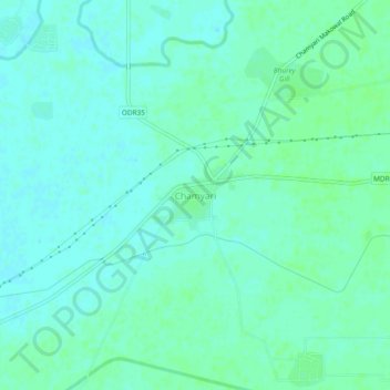
Name: Chamyari topographic map, elevation, terrain.

Location: Chamyari, Ajnala Tahsil, Amritsar, Punjab, 143103, India (31.83480 74.80135 31.87480 74.84135)

Average elevation: 230 m

Minimum elevation: 226 m

Maximum elevation: 234 m

Other topographic maps

Click on a map to view its topography, its elevation and its terrain.

Bajwa

India > Punjab > Ajnala Tahsil

Average elevation: 231 m

Aliwal

India > Punjab > Ajnala Tahsil

Average elevation: 228 m

Ajnala

India > Punjab > Ajnala Tahsil

Average elevation: 229 m

Ajnala

India > Punjab > Ajnala Tahsil

Average elevation: 229 m

Gear up for your next adventure:

🧴Insect Repellent - Protect yourself from bugs during outdoor adventures
🥾Trail Running Shoes - Lightweight and durable shoes for trail running
🔭Outdoor Binoculars - Lightweight binoculars for birdwatching and hiking
🧴Waterproofing Spray - Restore the DWR coating on jackets and tents
🥾Mountain Trail Shoes - High-traction shoes for mountain trails

As an Amazon Associate, this site earns from qualifying purchases at no extra cost to you.