Geolocate

Monipally topographic map

Click on the map to display elevation.

About this map

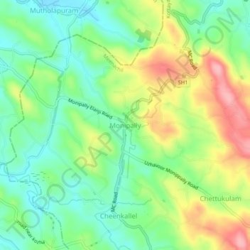
Name: Monipally topographic map, elevation, terrain.

Location: Monipally, Meenachil, Kottayam, Kerala, 686636, India (9.78837 76.55547 9.82837 76.59547)

Average elevation: 66 m

Minimum elevation: 14 m

Maximum elevation: 149 m

Other topographic maps

Click on a map to view its topography, its elevation and its terrain.

Melukavu

India > Kerala > Meenachil > Melukavumattom

Average elevation: 599 m

Poonjar-Thekkekara

India > Kerala > Meenachil > Vazhikadavu

Average elevation: 376 m

Chovoor

India > Kerala > Meenachil

Average elevation: 327 m

Gear up for your next adventure:

🧴First Aid Kit - Essential first aid supplies for outdoor emergencies
🧰Survival Kit - Essential gear for emergencies in the wilderness
🥾Trail Running Boots - Durable shoes designed for trail running
Camping Groundsheet - Protect your tent from moisture and dirt
🕶️Polarized Sunglasses - Reduces glare from snow and water at high elevations

As an Amazon Associate, this site earns from qualifying purchases at no extra cost to you.