Geolocate

Simbach topographic map

Click on the map to display elevation.

About this map

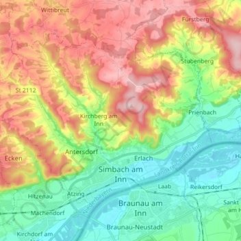
Name: Simbach topographic map, elevation, terrain.

Location: Simbach, Landkreis Rottal-Inn, Bavaria, 84359, Germany (48.25305 12.94150 48.32081 13.08112)

Average elevation: 425 m

Minimum elevation: 333 m

Maximum elevation: 555 m

Other topographic maps

Click on a map to view its topography, its elevation and its terrain.

Bergham

Germany > Bavaria > Landkreis Rottal-Inn

Average elevation: 362 m

Nagl

Germany > Bavaria > Landkreis Rottal-Inn > Hebertsfelden

Average elevation: 427 m

Putting

Germany > Bavaria > Landkreis Rottal-Inn > Wurmannsquick

Average elevation: 464 m

Walking

Germany > Bavaria > Landkreis Rottal-Inn > Wittibreut

Average elevation: 504 m

Gindering

Germany > Bavaria > Landkreis Rottal-Inn > Gangkofen

Average elevation: 465 m

Gear up for your next adventure:

🥫Freeze-Dried Meals - Lightweight, high-calorie nutrition for multi-day treks
🏕️Camping Hammock - Integrated protection for sleeping between trees
Family Camping Tent - Spacious tent suitable for family camping trips
🏃Hydration Running Vest - Carry water and maps close to your body for speed
🪑Ultralight Camping Stool - Compact seating for rest stops during long hikes

As an Amazon Associate, this site earns from qualifying purchases at no extra cost to you.