
Make a donation
Gear up for your next adventure:
As an Amazon Associate, this site earns from qualifying purchases at no extra cost to you.
Camelot Forest topographic map
Click on the map to display elevation.
Make a donation
Gear up for your next adventure:
As an Amazon Associate, this site earns from qualifying purchases at no extra cost to you.
About this map
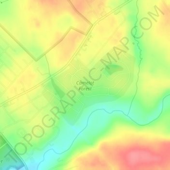
Name: Camelot Forest topographic map, elevation, terrain.
Average elevation: 514 m
Minimum elevation: 474 m
Maximum elevation: 548 m
Make a donation
Gear up for your next adventure:
As an Amazon Associate, this site earns from qualifying purchases at no extra cost to you.
Other topographic maps
Click on a map to view its topography, its elevation and its terrain.
Lake Naomi
United States > Pennsylvania > Monroe County > Tobyhanna Township > Pocono Pines > Pocono Lake
Average elevation: 549 m
Pocono Lake
United States > Pennsylvania > Monroe County > Tobyhanna Township > Pocono Pines
Average elevation: 537 m
Kalahari Indoor Waterpark
United States > Pennsylvania > Monroe County > Tobyhanna Township
Average elevation: 553 m