Geolocate

Aplaya topographic map

Click on the map to display elevation.

About this map

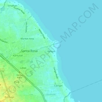
Name: Aplaya topographic map, elevation, terrain.

Location: Aplaya, Santa Rosa, Laguna, Calabarzon, 4026, Philippines (14.29444 121.10251 14.33444 121.14251)

Average elevation: 5 m

Minimum elevation: 0 m

Maximum elevation: 21 m

Gear up for your next adventure:

🥾Hiking Shoes - Durable and comfortable shoes for trail hiking
🔭Outdoor Binoculars - Lightweight binoculars for birdwatching and hiking
🧢Sun Hat - Wide-brim hat for sun protection
🪑Insulated Seat Pad - Protect your seat from cold rocks and wet logs
🍽️Titanium Camping Spork - Ultralight and indestructible eating utensil

As an Amazon Associate, this site earns from qualifying purchases at no extra cost to you.