Geolocate

Leoni topographic map

Click on the map to display elevation.

About this map

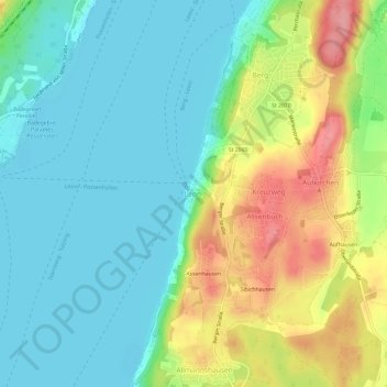
Name: Leoni topographic map, elevation, terrain.

Location: Leoni, Berg, Landkreis Starnberg, Bavaria, 82335, Germany (47.93479 11.32425 47.97479 11.36425)

Average elevation: 616 m

Minimum elevation: 581 m

Maximum elevation: 688 m

Other topographic maps

Click on a map to view its topography, its elevation and its terrain.

Berg

Germany > Bavaria > Landkreis Starnberg

Average elevation: 630 m

Tutzing

Germany > Bavaria > Landkreis Starnberg

Average elevation: 632 m

Pöcking

Germany > Bavaria > Landkreis Starnberg

Average elevation: 638 m

Gauting

Germany > Bavaria > Landkreis Starnberg

Average elevation: 593 m

Gear up for your next adventure:

🥾Waterproof Hiking Boots - Essential footwear for rugged terrain and wet Canadian trails
🥾Mountain Trail Shoes - High-traction shoes for mountain trails
🚑Survival Whistle - Signal for help across long distances in mountains
🧦Hiking Liner Socks - Thin base layer to prevent friction and blisters
👟Sport Hiking Sandals - Breathable footwear for water crossings and camp rest

As an Amazon Associate, this site earns from qualifying purchases at no extra cost to you.