
Profondeville topographic map
Interactive map
Click on the map to display elevation.
About this map
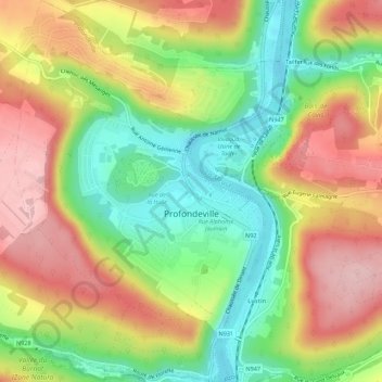
Name: Profondeville topographic map, elevation, terrain.
Location: Profondeville, Namur, Wallonie, 5160, Belgique (50.36070 4.84194 50.39582 4.88028)
Average elevation: 171 m
Minimum elevation: 76 m
Maximum elevation: 272 m
Other topographic maps
Click on a map to view its topography, its elevation and its terrain.
Bois-de-Villers
Belgique > Namur > Namur > Profondeville
Bois-de-Villers, Profondeville, Namur, Wallonie, 5170, Belgique
Average elevation: 223 m
Lustin
Belgique > Namur > Namur > Profondeville
Lustin, Profondeville, Namur, Wallonie, Belgique
Average elevation: 199 m