
Make a donation
Gear up for your next adventure:
As an Amazon Associate, this site earns from qualifying purchases at no extra cost to you.
Oswego topographic map
Click on the map to display elevation.
Make a donation
Gear up for your next adventure:
As an Amazon Associate, this site earns from qualifying purchases at no extra cost to you.
Oswego
Oswego is located on the southeastern shore of Lake Ontario at the mouth of the Oswego River, approximately 35 miles north of Syracuse and 69 miles east of Rochester. The elevation is 298 feet above sea level. The nearest city is Fulton, located south of Oswego and north of Syracuse.
Make a donation
Gear up for your next adventure:
As an Amazon Associate, this site earns from qualifying purchases at no extra cost to you.
About this map
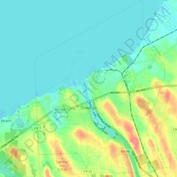
Name: Oswego topographic map, elevation, terrain.
Location: Oswego, Oswego County, New York, United States (43.42809 -76.53760 43.48138 -76.46932)
Average elevation: 91 m
Minimum elevation: 70 m
Maximum elevation: 132 m
Make a donation
Gear up for your next adventure:
As an Amazon Associate, this site earns from qualifying purchases at no extra cost to you.